Aspen Highlands Colorado (US)
Highland Bowl

Highland Bowl is a wonderful bowl accessible only by a hike or more specifically by taking the Loge Peak or Deep Temerity chairlift, followed by a snowcat ride and then followed by a hike after the trail becomes too narrow for the snowcat. I highly recommend a back-country backpack or harness or ski strap (sold by ski patrol if you need one) which can help you carry your skis as you might find it quite useful to have your hands free to articulate your poles as parts of the ascent are steep. Loosening your boots will definitely help make the hike more comfortable. The best snow is found on the North facing slopes (snow is more protected from direct sunlight) on the far side while the steepest terrain is on the South facing slopes. Highland Bowl also offers 1400 feet of ski-able vertical with wide open steep terrain, an infinite number of lines and a sustained average of 33 to 45 degrees of slope.
The bowl extends the resort's in-bound terrain, thus benefiting from avalanche control and other ski patrol services. Don't duck under the rope if the bowl is closed as it may take a while to blast and take care of avalanche dangers. The ski patrol will open Highland Bowl when it is safe. One must remember that on March 31st, 1984, three patrolmen (Chris Kessler, Tom Snyder, and Craig Soddy) died in an avalanche in Highland Bowl while doing avalanche control work, trying to prepare the bowl for the public. There is a shrine dedicated to them located on the right side of the Broadway run, just after exiting the Loge Peak lift.
The snowcat ride is free and is picked up at the top of the chairlift.

Snowcat approaches the loading zone

Snowcat loading

Snowcat riders are packed in for the short journey

Enter the main gate to hike the ridge leading to Highland Bowl

Hiking the ridge to Highland Bowl. There are opportunities to ditch the hike and ride.

The hike along the ridge gets narrow at points.

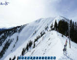
After about 30 to 45 minutes of hiking, the peak can be spotted. The peak is at 12,392 feet and will test you lung's efficiency. There is no shame it cutting out early if there is a fresh line of powder. The Temerity trees are often ignored and as a result, have powder staches.
Panoramic virtual tour of the hike and descent of Highland Bowl
(Best viewed in full screen mode)

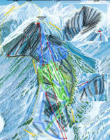
Highland Bowl trail map: 2,532 feet of vertical and 270 acres of terrain.
| Trail Name | Peak (ft) | Max Incline | Average Incline | Aspect |
|---|---|---|---|---|
| G-0 | 10,760 | 40 | 33 | North |
| G-1 | 11,195 | 43 | 36 | North |
| G-2 | 11,320 | 43 | 35 | North |
| G-3 | 11,440 | 40 | 38 | North |
| G-4 | 11,720 | 40 | 37 | North |
| G-5 | 11,900 | 38 | 36 | North |
| G-6 | 12,000 | 38 | 35 | North |
| G-8 | 12,200 | 38 | 37 | North-Northeast |
| Full Curl | 12,320 | 45 | 37 | Northeast |
| Ozone | 12,392 | 40 | 37 | Northeast |
| Be One | 12,350 | 45 | 40 | East Northeast |
| White Kitchen | 12,300 | 43 | 38 | East |
| Steep-N-Deep | 12,240 | 42 | 39 | East |
| B-Fore | 12,200 | 42 | 38 | East-Southeast |
| Grahamster's | 12,050 | 44 | 37 | East-Southeast |
| Boxcar | 12,000 | 42 | 37 | East-Southeast |
| Moshpit | 11,900 | 44 | 37 | East-Southeast |
| Ballroom | 11,800 | 43 | 37 | East-Southeast |
| Filip's Leap | 11,780 | 43 | 36 | East-Southeast |
| Whip's Veneration | 11,740 | 40 | 35 | Southeast |
| Y-12 | 11,480 | 38 | 36 | South |
| Triple Treat | 11,440 | 45 | 37 | South |
| Hot's Y's | 11,220 | 48 | 40 | South |
The G zone, B zone and Y zone are named after ski wax types. G zones face North (green wax), B zones face East (blue wax) and Y zones face South (yellow wax).
- Aspen Powder Tours - guided snowcat expeditions. Aspen Mountain.


